Stuart Allen is an artist whose work deals with fundamental elements of perception such as light, time, gravity and space. He has shown photographs, kites and sculpture in galleries and museums throughout the U.S. and abroad. His work is found in many private and public collections including the Tokyo Kite Museum, the Crocker Art Museum, the DiRosa Art Preserve, UNESCO Headquarters in Paris, and U.S. Embassy collections in Canada, Bulgaria, Kazakhstan, and the Republic of Georgia.
Allen has completed permanent public art commissions for the U.S. Embassy in Ottawa, Canada and the Police Headquarters building in Davis, CA. His work has been published in a variety of books and journals including: Picturing California’s Other Landscape: the Great Central Valley, Terra Nova: Nature and Culture, You Are Here: the Journal of Creative Geography, Zyzzyva and Artweek. Allen has lectured or served as a visiting artist at many fine institutions including the Los Angeles County Museum of Art, the Weisman Art Museum, the Atlantic Center for the Arts, and a number of university art departments nationwide.
Allen studied architecture at Kansas University and graduated from the photography and video department of the Kansas City Art Institute in 1994. He lives in San Antonio, Texas with his wife Kelly Lyons, their daughter Aidan and son Vincent.
Allen is represented by the following galleries: PDNB, Dallas, TX; JayJay, Sacramento, CA; Jan Manton Art, Brisbane, Australia; Haw Contemporary, Kansas City, MO.
Stuart Allen, artist, photographer, sculptor, public art, kite, kite maker, art consultant, Jayjay, haw contemporary, pdnb gallery, science and art
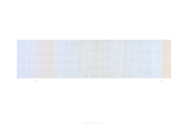
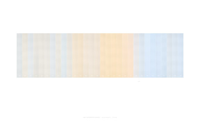
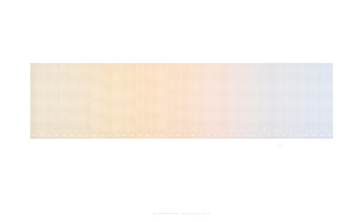
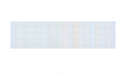
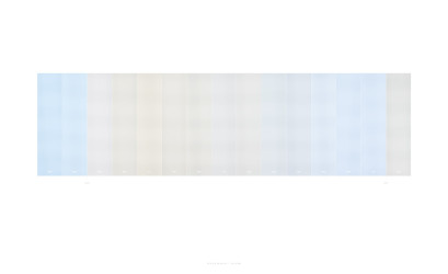
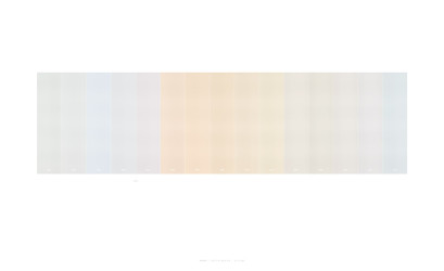
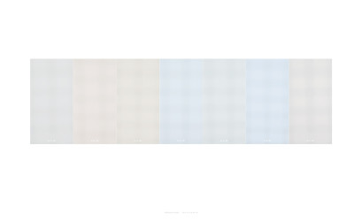
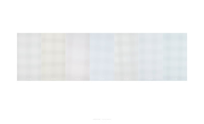
The changing color of daylight is recorded at different intervals of time using a piece of white sailcloth attached to a camera lens. The resulting photographs are cropped to vertical strips, then assembled to make one print; a portrait of the light in one place, in one timeframe.
At the base of each strip, small numbers indicate the time of day for a given frame. Sunrise and sunset times are marked when relevant. Titles indicate the location in longitude / latitude coordinates.
Excerpt from a review by Wendy Atwell, 2007.
In the Light Maps series, [Allen] clips a screen, made of the same white sailcloth he uses for his kites, onto his camera. With the camera’s automatic light-balancing sensor disabled, Allen photographs light from a single point, identified in the works’ titles by each site’s geographic coordinates.Sunset – One Photograph Every Two Minutes / 29° 27’ 8” N ~ 98° 30’ 4” W / 03 – 16 – 2007 conveys a delightfully surprising variety of colors. Allen is intent on recording an unmediated and pure representation of color as created by the sun, intervening atmospheric particles and everything else that conspires to make the color of the day… [These works] felt like a gift, as if he had done me this great favor of caring enough to record a beauty that is always passing and ephemeral. As records of moments that technically cannot be observed by the human eye, the Light Maps works give the gift of awareness and prompt a desire to look more carefully.